OVERVIEW: A nice loop walk taking in Ingra Tor, and South Hessary Tor, as well as Devonport Leat. Includes the option to stop in Princetown for snacks and drinks. Could also add on Sharpitor while in the area.
START: Sharpitor Car Park (SX 560 708)
END: As above (looping route)
DISTANCE: 9 Miles
TERRAIN: Mostly path. Slightly steep downhill section near Devonport Leat Aqueduct.
 |
| Rough route: OS Map |
From the Sharpitor car park I headed north west along a fairly well defined grassy path with Leeden Tor looming over my right hand side.
Path from the car park
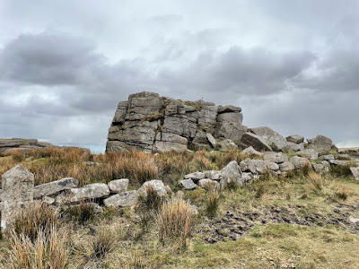
Eventually I picked up a more substantial gravel path which I followed in a roughly northerly direction. I could easily see Ingra Tor up ahead. I followed this path and then climbed up over the top of Ingra Tor. However, you could also follow the path as it curves around the back if you didn't fancy the climb.
Path to Ingra Tor
Ingra Tor
View From Ingra Tor
From Ingra I followed the path that runs east behind the Tor. This path eventually took me through an old railway bridge (SX 562 724). The path begun to bend to the left and I could see Swelltor Quarries in front of me. Just before I reached Swelltor I took the track heading uphill (SX 563 728) with Swelltor on my left and a boundary wall on my right.
Old Railway Bridge
Looking back along path, Swelltor to right
At the top of this path I followed it NE away from Swelltor until I reach a multidirectional junction (SX 565 732). At this point I turned right onto the Dartmoor Way High Moor Link path. This path weaves its way in a roughly easterly direction to Princetown. From the path I could see some old settlements and the remnants of tin mining activity. Once in Princetown there are a selection of Cafés to choose from if you want some coffee and cake... Or a burger and chips like I had.
From Princetown I headed down a path that heads to the South East towards South Hessary Tor. I followed this path until I came to a crossroads (SX 602 708). At this point I turned right (or roughly westerly).
Path to South Hessary Tor
 |
| South Hessary Tor |
As I headed west along this new path I was walking parallel to Devonport leat (which was up to my north). Eventually I stumbled upon an old restored cross just off to the left (SX 591 702). Not long after this cross I started looking for a way to head off the path north to reach Devonport Leat. I found a good place to head up was approximately SX 58572 70355.
 |
| Restored Cross |
Once I had found Devonport Leat I just followed it all the way down the hill, and along the man made falls until I got to a small Aqueduct (SX 257 713). If you want to risk getting wet like I did then you can jump across the Leat. However, if you want to stay dry then you can safely cross on one of the many stone slab bridges before you get to the falls.
 |
| Devonport Leat |
 |
| Devonport Leat with Aqueduct at bottom of falls |
To cross the aqueduct I followed a small path that runs on the right hand side of the water. Once across I continued to follow the leat until it enters a forested area (SX 569 709). At this point I turned right and headed up the hill with the forested area on my left hand side.
 |
| Leat with forested area in the distance |
I continued to head up this path until I eventually reached the B3212. At the road I took a left turn and carefully followed it until I found myself back at the carpark.
If you have spare time, like I did, you could have a quick rest at the car and then head back across the road to climb Sharpitor (SX 559 703), which is the large Tor to the south of the Carpark.
 |
| Sharpitor |
 |
| Sharpitor view to Burrator, and Plymouth in the distance |


Comments
Post a Comment